
Answering the IBM Call for Code
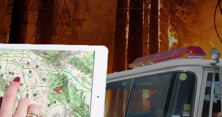
Emergency management is probably not the first industry that you think of in connection with geospatial technologies, but GIS is opening many exciting new opportunities to protect the public. GIS helps emergency managers better visualize information and gain comprehensive situational awareness to make informed decisions before, during, and after a crisis or planned event.
Last year, IBM hosted its inaugural Call for Code competition to encourage developers to help mitigate natural disasters using these emerging, sustainable software solutions. IBM called on 22 million developers to create technology applications “that improve disaster preparedness and relief, build resilient communities, and safeguard the health and well-being of individuals and institutions.” That’s a call that geographIT, a division of EBA Engineering, eagerly responded to.
Our software development team partnered with the Los Angeles Homeland Security Advisory Council (HSAC) to enter the competition by developing new functionality for SALUS, HSAC’s crisis and event management platform. SALUS aggregates and shares public safety and emergency management geospatial data with first responders and emergency officials. For example, local fire departments have used SALUS to fight wildfires in Southern California, and local law enforcement officials have used this data to plan emergency routes for events such as the Los Angeles Marathon.
With a rapidly approaching submission deadline of only a month, the team got to work on implementing a solution for sharing ArcGIS Online data in a user-friendly way for non-GIS professionals, streamlining this process through a custom “landing page” and web application. The app employs several exciting, cutting-edge technologies, including Esri’s newly-released Python Application Programming Interface (API) for managing the ArcGIS Online content behind the scenes and React.js, a web development framework maintained by the Facebook development team. It is hosted in the IBM Cloud’s Kubernetes Service, a solution originally designed by Google for managing containerized applications in a serverless environment. (For you Greek scholars, Kubernetes, or κυβερνήτης, means “captain” or “navigator.”)
The resulting application helps HSAC and their user community quickly and efficiently share otherwise-inaccessible geospatial data with each other or even with the public. This sharing capability meets a critical need for public safety decision-makers to have as much information as possible at their fingertips when making potentially life-or-death choices!
Near the end of October 2018, the team received the news that our submission had become a finalist in the Call for Code by winning the 2018 Stanford Hackathon, a regional division of the competition.
Hundreds of submissions from developers around the world were evaluated in the final competition by a panel of noteworthy judges, including Linus Torvalds, the creator of the Linux operating system, and former President Bill Clinton. Congratulations to the winning team, Project OWL, for their innovative and potentially life-saving “clusterduck” emergency communication solution!
While our team didn’t end up winning the worldwide prize, we are still extremely proud of what we accomplished, particularly in such a short period of time. The project continues to improve the lives and safety of people not only in California, but across the country. And our team continues to work with HSAC to expand their SALUS sharing platform.
Michael Mattaini is a software developer for EBA Engineering, Inc. He can be reached at 717.399.7007 or at michael.mattaini@ebaengineering.com.