
Regional NG9-1-1 Data Sharing in Pennsylvania: A Model for the Rest of the Nation
During an emergency, if road centerline data doesn’t match up from county to county, it can lead to some serious 9-1-1 routing and dispatch problems. In a previous blog, Andrew Smart discussed how six counties in Southeast Pennsylvania are leveraging GIS and other technology to modernize regional data sharing and reduce errors.
In part, this collaboration began in response to a nationwide effort to transition to Next Generation 9-1-1 (NG9-1-1), a more advanced 9-1-1 system that enables emergency callers to transmit voice, photos, videos, and text messages to call centers and also transmit the caller’s latitude/longitude to route the closest first responders to the caller’s location.
GIS is obviously critical to NG9-1-1, since counties need accurate GIS datasets like address points, road centerlines with road names and address range data, cell towers, and PSAP boundaries to accurately map a caller’s location and route emergency responders. One challenge to NG9-1-1 development, though, is that county GIS programs have traditionally focused on only maintaining their own GIS data within their boundaries, resulting in inconsistent road centerline data across county boundaries that can lead to some major routing and dispatch problems.
Six counties in the Southeast Pennsylvania Task Force (SEPATF) region (Philadelphia, Bucks, Berks, Delaware, Chester, and Montgomery) have been working collaboratively to prepare for the NG9-1-1 changes. SEPATF has been working closely with a team of GIS experts from geographIT®, a division of EBA Engineering, Inc., and we have been sharing about this effort in EBA’s blog and at various industry conferences because we see it as both a replicable case study and a success story of effective NG9-1-1 collaboration.
When Andrew wrote his blog back in early 2017, the SEPATF collaboration had already helped reduce GIS data errors. In the 2 years since, there have been some exciting updates to the effort!
One very important update is that the National Emergency Number Association (NENA) NG9-1-1 GIS Data Model has officially been adopted and is no longer in draft form. As described in Andrew’s post, the draft status of the data model did not delay work in Southeast Pennsylvania, but the long-term draft status did prevent progress in other areas of the state. With that roadblock removed, work is progressing in more areas than the Southeast.
In 2018, both new participants and new datasets were added to the original SEPATF effort. SEPATF worked with geographIT to add the response zone layers to the monthly NENA conversion process. Each county in the region provided their EMS, fire, and police polygon layers for conversion to the NENA standard and for inclusion in the monthly regional dataset creation.
This effort, funded by an interconnectivity grant from the Pennsylvania Emergency Management Agency (PEMA), provided the region with valuable information on what work still needs to be done to make the data NENA compliant.
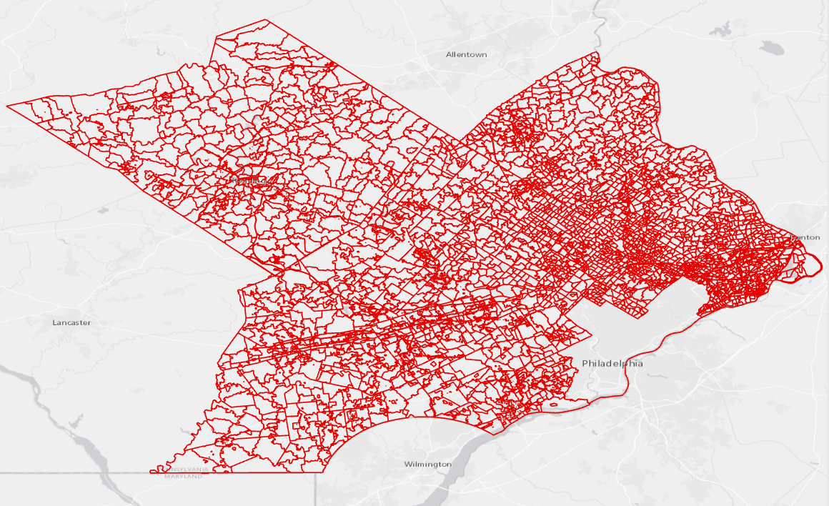
Regional Fire and EMS Response Zones:
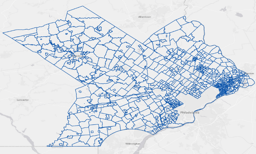
Regional Police Response Zones:
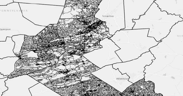
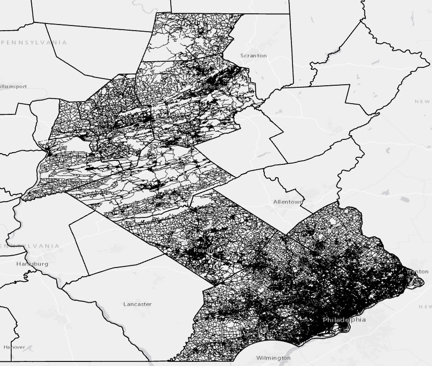
Counties in the East Central PA Regional Task Force (ECTF) joined the NG9-1-1 GIS Collaboration Portal in 2018 by contributing their road centerline data to the monthly county-to-NENA conversion process. This effort demonstrated the ease of adding new data to the NG9-1-1 GIS Collaboration Portal and started the ECTF members down the path to NENA compliance.
Expanded ECTF and SEPATF Regional NENA Centerline Layer:
So far, 2019 is already full of plans to further advance NG9-1-1 GIS readiness in Pennsylvania. SEPATF is exploring options to add their address data points to the NG9-1-1 GIS Collaboration Portal, while PEMA interconnectivity grant funding is again providing opportunities for more regional taskforces to convert their GIS data into the NENA format and contribute to the NG9-1-1 GIS Collaboration Portal.
By the end of 2019, we should see the addition of several more counties involved with the effort and very much on their way to NG9-1-1 readiness!
Here are a few things to keep in mind if you are in the beginning stages of your own NG9-1-1 efforts:
- Don’t wait for your data to be perfect or you’ll never get started.
- Apply for grants as a region in order to show the counties’ willingness to work together and to maximize funding opportunities.
- Leverage GIS datasets created for NG9-1-1 for other purposes throughout your enterprise. Updated imagery and address points are valuable datasets to many agencies.
- Remember that communication and coordination between the 911 and GIS partners is critical, both within your organization and in your region.
We will continue to update you on this important project’s progress, and we hope that Pennsylvania can serve as a model to other parts of the country for NG9-1-1 collaboration.
Stacey Sekkes, GISP, is a project manager for geographIT, a division of EBA Engineering, Inc. She was a member of PEMA’s NG9-1-1 Workgroup and a project coordinator for the SEPATF NG9-1-1 regional GIS initiatives. She can be reached at 717.399.7007, stacey.sekkes@ebaengineering.com, or on LinkedIn.