
Leveraging GIS in the Asset Management Planning, Coordination, and Decision-Making Process
How do municipalities or water authorities change from a reactive approach to managing asset failures to a proactive program that supports preventative maintenance?
Many agencies track their asset inventory through paper maps, forms, and spreadsheets that are often scattered in various locations around an office. Information also includes the vast employee knowledge gained through years of working on a water/wastewater system, and as employees retire, that institutional knowledge is lost. This is a challenging environment for accurately meeting regulatory reporting requirements, making repair versus replacement determinations, projecting where a critical failure may occur next, or anticipating the consequences of a failure.
Instead, leveraging GIS for asset management can help ensure that the right information is available to plan, coordinate, and make informed asset management decisions.
What information is needed to make informed decisions?
In most cases, being able to map the location of asset failures is the first step in the process. This allows you to view geographic and temporal trends of asset failures and formulate questions that will help determine the cause and consequences of asset failures.
Tracking asset age, repair history, and repair costs will also provide supporting data to determine whether an asset should be repaired or replaced given the asset’s life cycle status. This provides essential information to justify future spending on new equipment.
Can GIS work with existing asset management tools?
GIS can be combined with commercially available asset management software to provide easy-to-use mobile apps that help track, plan, and analyze the full inspection and repair history of an asset. GIS can also be leveraged to analyze spatial and temporal trends of asset failure rates, current conditions, and useful remaining life.
For example, GIS information can be displayed as heat maps that show the general density of work orders performed by type or cost of repairs. When mapped, GIS data provides useful insights about what might cause reoccurring maintenance and repairs, from restaurants that aren’t using grease traps to aging ductile iron water mains impacted by acidic soil.
Asset management apps integrated with GIS data also provide tools that quickly deliver a return on investment by improving workflow processes, such as:
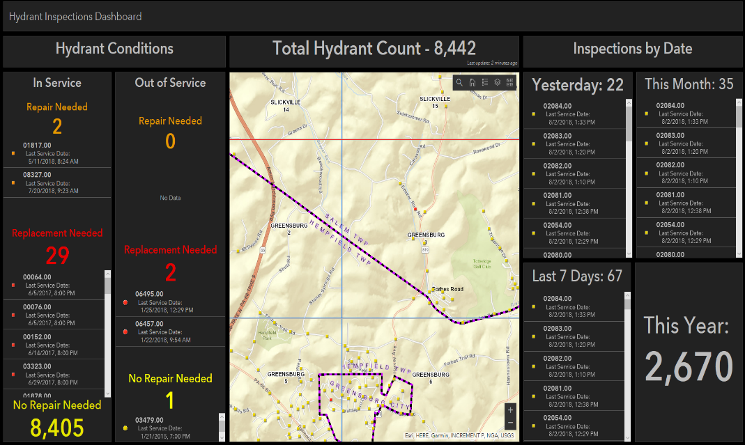
- Using integrated dashboards to track work orders completed and repairs still open by combining maps, charts, and tables. This management level summary quickly communicates the big picture status of inspection and maintenance work orders while ensuring nothing is left unrepaired.
- Configuring custom report templates to retrieve required asset inspection and maintenance information in the desired format.
- Scheduling and communicating job assignments to staff and tracking the status of open work orders.
- Eliminating redundant trips to the office to access asset records by providing GIS data and scanned documents in the field.
- Using mobile devices (rather than paper records transcribed and entered by office staff) to update asset inventories and inspection and repair data right from the field. Errors are also greatly reduced because this information is captured once while the asset is being observed in the field.
Incorporating GIS and asset management tools helps to improve analysis, planning, communication, and decision-making, while also demonstrating to customers and stakeholders that the system is cost-conscious and complies with industry best practices. In all, GIS integrated with asset management data provides essential tools to support a maintenance management program and informed decisions.
Joe DeLuca is a project manager for EBA Engineering’s geospatial technologies and asset management services division. He can be reached at 717.510.9873 or joseph.deluca@ebaengineering.com.